For boaters and watersports enthusiasts who want to run with the best, the rugged GPSMAP 78 features crisp color mapping, high-sensitivity receiver, new molded rubber side grips, plus a microSD™ card slot for loading additional maps. And it floats!
Explore
TGPSMAP 78 comes with built-in worldwide basemap, so you can navigate anywhere with ease. And, like the rest of the 78-series, the 78 is IPX7 waterproof and even floats in water.
Keep Your Fix
With its high-sensitivity, WAAS-enabled GPS receiver and HotFix™ satellite prediction, GPSMAP 78 locates your position quickly and precisely and maintains its GPS location even in heavy cover and deep canyons. The advantage is clear — whether you’re in deep woods or just near tall buildings and trees, you can count on GPSMAP 78 to help you find your way when you need it the most.
Add Maps
Adding more maps is easy with Garmin's wide array of detailed marine, topographic and road maps, available on microSD card. Conveniently plug in BlueChart® g2 preloaded cards for a great day on the water or City Navigator NT® map data for turn-by-turn routing on roads (see maps tab for compatible maps). The card slot is located inside the waterproof battery compartment, so you don't have to worry about getting it wet. GPSMAP 78 also supports BirdsEye™ Satellite Imagery (subscription required), that lets you download satellite images to your device and integrate them with your maps. In addition, the 78 is compatible with Custom Maps, free software that transforms paper and electronic maps into downloadable maps for your device.
Get Connected
You've been busy exploring and now you want to store and analyze your activities. With a simple connection to your computer and to the Internet, you can get a detailed analysis of your activities and send tracks to your outdoor device using Garmin Connect™. This one-stop site offers an activity table and allows you to view your activities on a map using Google™ Earth. Explore other routes uploaded by millions of Garmin Connect users and share your experiences on Twitter® and Facebook®. Getting started is easy, so get out there, explore, and share.
Find Fun
GPSMAP 78 supports geocaching GPX files for downloading geocaches and details straight to your unit. By going paperless, you're not only helping the environment but also improving efficiency. GPSMAP 78 stores and displays key information, including location, terrain, difficulty, hints and descriptions, which means no more manually entering coordinates and paper print outs! Simply upload the GPX file to your unit and start hunting for caches. Slim and lightweight, 78 is the perfect companion for all your outdoor pursuits.
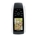
GPSMAP 78: Colorful maps, durable design and buoyant — everything a mariner needs.
View all |
Collapse all
Accessories Kits

Rechargeable NiMH Battery Kit
010-11343-00
Mounts

Marine Mount
010-11441-00

Auto Mount
010-11441-01
Cables

Vehicle Power Cable with PC Interface
010-10165-00

Vehicle Power Cable
010-10085-00

Power/Data Cable
010-10082-00

Vehicle Power Cable
010-10851-11

Serial Data/Power Cable
010-11131-00

USB Cable
010-10723-15

USB Cable
010-10723-01
Cases and Covers

Carrying Case
010-10117-02
Adapters

A/C PC Adapter (U.S., 4-pin)
010-10277-00
Antennas

GA™ 30 GPS Antenna
010-00872-00

GA 25MCX Remote GPS Antenna (Low Profile)
010-10702-00

Adapter Cable (MCX to BNC)
010-10121-00

Suction Cup Mount for GA 25 External Antenna
010-10871-00
Lanyards, Straps, Holsters and Clips

Lanyard
013-00005-00
On the Trail Maps

Temporarily out of stock
010-D1281-00
Data Cards

4 GB microSD™ card with SD™ adapter
010-10683-05