GPSMAP® 585 Plus
Durable devices that go wherever you go and track your precise location in the process. Go farther than ever before when hiking and finding adventure.
The Power of Garmin CHIRP
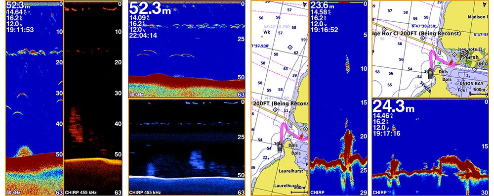
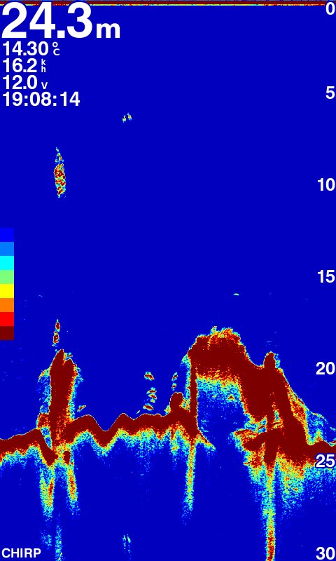
The built-in sonar capabilities of GPSMAP 585 Plus includes CHIRP sonar, the most sophisticated sonar technology available for the fishing and boating public. CHIRP sonar provides amazingly clear target separation and definition because it puts even more energy onto the target than traditional sonar. It also includes sonar-recording capability that coordinates the timing of the sonar return with your boat’s position and saves digital information for playback on a computer using HomePort™ planning software. Use the user data sharing cable to share waypoints and routes between multiple devices.
Clearest Scanning Sonar on the Water
Garmin CHIRP ClearVü scanning sonar gives you a nearly photographic image down below your boat. Traditional Garmin HD-ID™ sonar and ClearVü scanning sonar are combined into 1 transducer.
With the Best Maps on the Water Supporting
Two standard SD™ card slots provide expandable memory for accessory map purchases such as BlueChart® g2, BlueChart® g2 Vision®. The BlueChart g2 Vision provide exclusive Garmin Auto Guidance, a technology that directs you to your hot spots. Based on your boat’s specifications, Auto Guidance instantly creates a visual path you can follow to avoid shallow water and other charted obstructions.
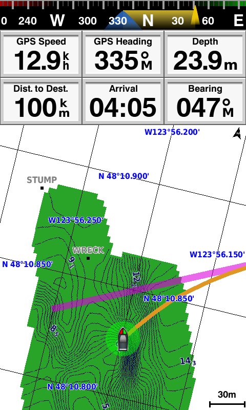
Quickdraw Contours: Create Your Own HD Maps
Quickdraw Contours is a free, easy-to-use software feature already installed on your GPSMAP 585 Plus. It instantly creates your own personalized HD fishing maps on screen with 1-foot contours. Tailor the maps as needed; you own them. Keep the data for yourself, or share it with Garmin or your friends. No special surveying expertise is required. You just fish while Quickdraw Contours creates maps. There’s no waiting around or sending your files away like other mapping software requires — your results appear instantly.
Compatible with GPS, GLONASS and BeiDou
With multi positioning modes supports to GPS, GLONASS and BeiDou three powerful systems. It is quick and easy to drop up to 12,000 accurate waypoints and find your way back to your secret fishing hot spots. Huge capacity memory to help fishermen record danger spot(Mark) and the destination(Waypoint).
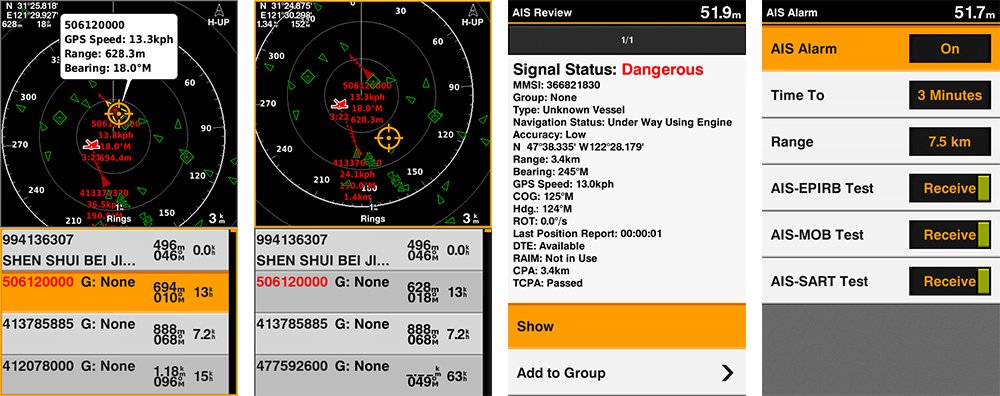
AIS Radar Support
Show you the detailed AIS Radar view and AIS list at the same page. Move the cursor and review particular item on the radar view to see the detail information of highlighted vessel. Drop VRM/EBL and measure distance on the AIS Radar view window and to focus a AIS vessel through the AIS list to see the detail of it.
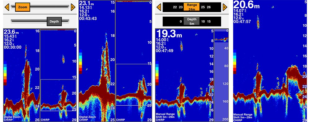
Digital Zoom and Shift Zoom Supporting
Digital Zoom and Shift Zoom features let you control your owned display portion as what you prefer to shows in detailed.
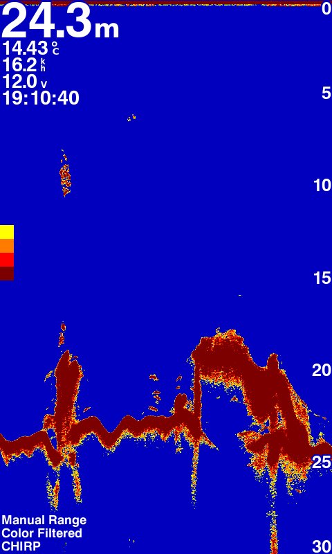
Color Filter for Traditional Sonar Display
8 color levels let users can switch the toggle to turn ON/OFF the specific color on traditional sonar page with their owned preference to show the sonar display.
Digital Zoom and Shift Zoom Supporting
Digital Zoom and Shift Zoom features let you control your owned display portion as what you prefer to shows in detailed.
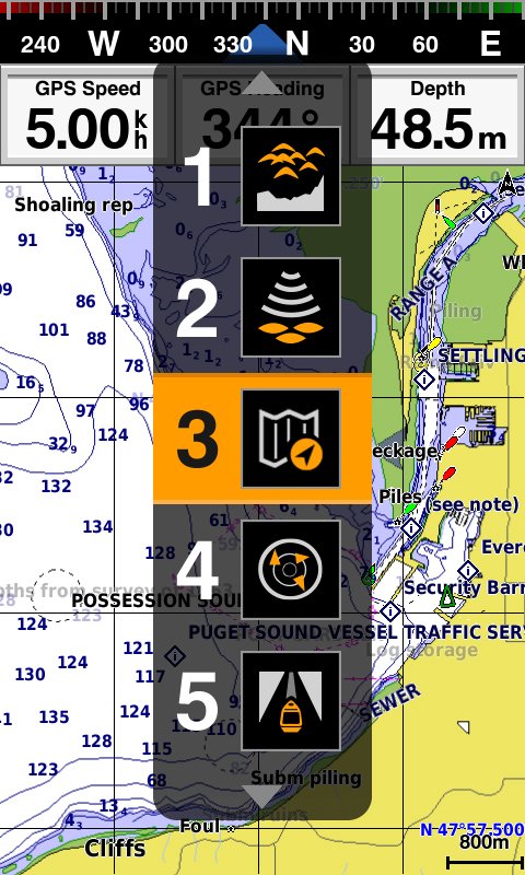
Enhanced Auto Guidance
Just enter the location where you want to go and patented Garmin Auto Guidance technology instantly searches through relevant charts to create a safe, virtual pathway on the display that helps you avoid low bridges, shallow water and other charted obstructions en route.
With enhanced Version 2.0, you have access to more features and capabilities. You’re able to adjust the calculated Auto Guidance pathway by inserting via points at interim stops or landmarks along your desired route. You can easily review hazard points along your calculated path. Other 2.0 enhancements give you the ability to calculate arrival times at any point on your route (great for timing arrivals to correspond with bridge openings and other time-critical events). Better still, you can now save your plotted Auto Guidance paths for future navigation by backing them up on an SD™ card with your BlueChart g2 Vision or LakeVü HD Ultra cartography¹.
Cross Products Comparison
FF 350 Plus | FF 650 Plus | GPSMAP 585 Plus | |
|---|---|---|---|
Display size | 6” color, portrait | 6” color, portrait | 6” color, portrait
|
Display resolution | 480 x 800
| 480 x 800 | 480 x 800
|
GPS/GLONASS/BeiDou | – | – | |
GPS antenna built-in | – | – | |
External GPS antenna support | – | – | |
Sonar output power(RMS) | 300W
| 600W
| 600W
|
Sonar Frequency | 50/77/200kHz | 50/77/200kHz CHIRP (Low, Mid, High) | 50/77/200kHz CHIRP (Low, Mid, High)
|
ClearVü | – | – | – |
Scanning sonar frequency | 260/455/800kHz | CHIRP 260/455/800kHz | CHIRP 260/455/800kHz
|
Chart support | • (All Garmin Chart/KMZ custom map) | ||
Quickdraw™ Contours | – | ||
Waypoint/Route/Track/Active Track | (12000/200/0 /1) | ||
IPX7 Waterproof | – | – | – |
NMEA 0183/RS422 | – | – | |
SD Card | (2 standard SD)
| ||
Multi-language support | – | – | – |
In The Box
GPSMAP 585 Plus
Power/data cable
Bail Mount
Hardware
Documentation
Specification
Physical Performance | ||
|---|---|---|
Physical dimensions | 176.0 mm x 190.0 mm x 66.0 mm (6.93” x 7.48” x 2.60”)
| |
Display size, WxH | 2.83″ x 5.36″; 6.0″ diagonal (72.0 mm x 136.2 mm; 152.4 mm diagonal)
| |
Display resolution, WxH: | 480 x 800 pixels
| |
Display type: | WVGA display
| |
Weight: | 816.0 g (1.80 lbs)
| |
Water rating | IPX7
| |
Power consumption | 7.6 W
| |
Mounting options | Bail or flush
| |
Maps & Memory
| ||
Preloaded maps | GPSMAP 585 Plus, APAC (worldwide basemap)
GPSMAP 585 Plus, w/g2, SEA (built-in SEA g2 chart) | |
Accepts data cards | 2 standard SD | |
Waypoints | 12,000 | |
Routes | 200 | |
Active Track | one 50,000 points active track
| |
Sonar Features & Specifications
| ||
Transmit power | 600W (RMS)
| |
Voltage range | 10V – 36V DC input
| |
Sonar Frequency
| 50/77/200kHz
| |
ClearVü™ | (built-in)
| |
Scanning Sonar Frequency | 260/455/800kHz
| |
Scanning Sonar Frequency | 260/455/800kHz
| |
Maximum depth | 1,750 ft freshwater, 830 ft saltwater (depth capacity is dependent on water bottom type and other water conditions)
| |
Garmin Sonar compatible | yes
| |
Bottom lock (shows return from the bottom up) | yes
| |
Water temperature log and graph | yes
| |
Split-screen zoom | yes
| |
Split-screen zoom | yes
| |
Fish Symbol ID (helps identify fish targets) | yes
| |
Sonar history rewind | yes
| |