Skip to content

GPSMAP® 9019

Durable devices that go wherever you go and track your precise location in the process. Go farther than ever before when hiking and finding adventure.

WELCOME TO 4K PARADISE

See fish and structure in maximum detail when you pick your display color, your location and your sonar for your day on the water with the STRIKER Vivid 4cv fishfinder with transducer.

The bright 6″, 7″ or 9″ touchscreen display with keyed-assist is user-friendly and easy to read.

Good things come in threes. Supports three sonar types, that is: Garmin traditional, ClearVü™ and SideVü™ sonars¹.

Improved detail? Check. Distinguished targets? Yep. That’s the beauty of high-contrast vivid colour palettes.

If you’re running another ECHOMAP UHD2 chartplotter, you can wirelessly share sonar, waypoints and routes.

Want our best in mapping? Who doesn’t? Select chartplotters come with Garmin Navionics+™ mapping.

PLOT YOUR PARADISE

CONNECT

SOFTWARE UPDATES

UP TO 7 TIMES FASTER PROCESSING POWER THAN PREVIOUS GENERATIONS

ENGINE MONITORING

UP TO 7 TIMES FASTER PROCESSING POWER THAN PREVIOUS GENERATIONS

CUSTOM LOOK

UP TO 7 TIMES FASTER PROCESSING POWER THAN PREVIOUS GENERATIONS

FROM YOUR PARADISE

SEE YOUR CHARTS, view entertainment AND MORE IN 4K

NAVIGATE

MAPPING

Navigate with optional Garmin Navionics+ charts that include Auto Guidance+ technology, daily updates and more2 (subscription required).

PREMIUM CHARTS

Get support for Garmin Navionics Vision+ charts with premium relief shading and satellite imagery.

KNOW WHERE YOU ARE

Get your precise location with the included GPS 24xd position receiver and antenna.

AUTOPILOT

Control the autopilot with any compatible chartplotter on the network with autopilot integration.

CLARITY, CONTROL AND LUXURY AT THE HELM

INTEGRATE

CONNECT CAMERAS

Get extensive camera support and control to see footage directly on the chartplotter.

SURROUND VIEW SYSTEM

Get a bird’s-eye view with support for our Surround View Camera System (accessory purchase required).

CONTROL WITH YOUR WATCH

Connect to your chartplotter with your compatible Garmin smartwatch.

WIRELESS CONNECTIVITY

Connect compatible devices with integrated BLUETOOTH® and ANT® technologies.

FISH MAPPING

Get comprehensive fishing data with the Fish Mapping feature from SiriusXM® Radio (accessory purchase and subscription required).

VERBAL COMMANDS

Use spoken commands to control the chartplotter through your compatible headset.

WEATHER-RESISTANT

The GPSMAP 9000 chartplotter is built for harsh marine conditions with an IPX7 water-resistance rating.

CONNECTION IS KEY

BUILD AN EXTENSIVE, TOP-OF-THE-LINE ECOSYSTEM

PREMIUM CHARTPLOTTER

The 4K resolution IPS sunlight-readable touchscreen display is available in the industry’s largest integrated chartplotter size. Edge-to-edge design provides a seamless and luxurious modern look.

FASTER. MUCH FASTER.

Processing power is 7 times faster than previous generations for superior performance; draw charts quickly

GARMIN BLUENET NETWORK

Build extensive networks with multiple chartplotters, cameras, radars and sonars — and enjoy 10 times faster networking speeds with minimal lag.

ENTERTAINMENT OPTIONS

Enjoy audio and video integrations that allow you to show and hear the same video throughout the screens and speakers on your network.

HIGH-DEFINITION SONAR

Fish in stunning high definition. Hook up to any of our sonar modules, and view sonar targets on the 4K display (transducers sold separately).

CONNECT YOUR ECOSYSTEM

Take command through digital system integrations to monitor, automate and control your vessel. The chartplotter uses the NMEA 2000® and NMEA 0183 networks to connect to your compatible accessories.

THE SPEED YOU NEED

UP TO SEVEN TIMES FASTER PROCESSING POWER AND GIGABIT SPEEDS ON THE Garmin BlueNet™ NETWORK

Specification

General
Dimension
18.0″ x 12.0″ x 2.7 (45.7 cm x 30.5 cm x 6.9 cm)
Weight
14.16 lbs (6.42 kg)
Water rating
IPX7
TOUCHSCREEN
DISPLAY TYPE
4K, IPS
DISPLAY SIZE
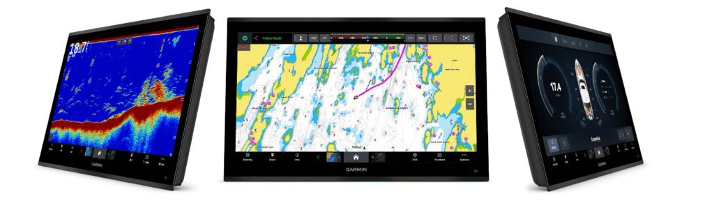
16.1″ x 9.1″ x 18.5″ diagonal, 40.9 cm x 23.0 cm x 46.9 cm diagonal
DISPLAY RESOLUTION
3840 x 2160 pixels
Mounting options
Flush or flat
INPUT
Touchscreen
Maps & memory
Accepts Data Cards
2 SD Cards
Compatible with Garmin SD card reader
Waypoints
5000
Track points
50,000
Tracks
50 saved tracks
Navigation Routes
100
Sensors
GPS
GLONASS
Galileo
BEIDOU
Receiver
10 Hz (included receiver)
NMEA 2000 Compatible
Supports WAAS
SUPPORTS MULTI-BAND, MULTI-CONSTELLATION GPS
Optional map support
BLUECHART G3
BLUECHART G3 VISION
LAKEVÜ G3
LAKEVÜ G3 ULTRA
GARMIN NAVIONICS+™
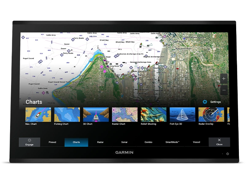
GARMIN NAVIONICS VISION+™
TOPO 100K
STANDARD MAPPING
GARMIN QUICKDRAW CONTOURS
Chartplotter features
Smart Mode Compatible
AIS
DSC
Supports Fusion-Link™ compatible radios
GSD Black Box Sonar Support
GCV Black Box Sonar Support
ActiveCaptain® compatible
yes
GRID (Garmin Remote Input Device) compatible
Wireless Remote Compatible
Sailing Features
Spoken audio alerts
OneHelm support
Electrical Features
Power input
10 to 35 Vdc
Typical current draw at 12 VDC
4.6A
Maximum current draw at 12 VDC
5.0A
Maximum power usage at 10 VDC
60W
Sonar features & specifications
Displays sonar
POWER OUTPUT
yes (with GCV™ black box, sold separately)
Traditional sonar (dual frequency/beam)
yes (with GCV™ black box, sold separately)
SideVü
yes (with GCV™ black box, sold separately)
Panoptix™ sonar
LiveScope
Connections
NMEA 2000® PORTS
1
NMEA 0183 Input (Rx) Ports
1
NMEA 0183 output (Tx) ports
1
Video input ports
1 (BNC composite); 1 HDMI (HDCP compliant)
Video output ports
1 HDMI
J1939 ports
1
Garmin Marine Network Ports
4
USB ports
yes (2x USB-C)
BLUETOOTH® pairing
ANT® (Connectivity)
Garmin Wi-Fi network (local connection)
Audio output